


Drones for Site Surveys in Vancouver & Port Coquitlam: The 2026 Guide to Aerial Data
- Mar 30
- 11 min read
Traditional land surveying in British Columbia is no longer just a logistical hurdle; it's a financial drain that delays project kick-offs by an average of 14 days. Relying on ground crews to navigate the steep, treacherous slopes of North Vancouver or other challenging terrains across the Lower Mainland creates unnecessary safety risks and bloated budgets. Utilizing drones for site surveys isn't a futuristic concept for 2026; it's the baseline for firms that prioritize precision and speed.
You've likely experienced the headache of receiving survey data that won't talk to your modern BIM or security software, forcing your team into manual workarounds. We believe technology should bridge gaps, not create them. This guide reveals how professional drone mapping delivers centimetre-level accuracy and cuts data collection time by 75% compared to conventional methods. You'll learn how to leverage high-resolution 3D models to empower your stakeholders and integrate aerial data into your broader technology infrastructure across Vancouver and Port Coquitlam.
Key Takeaways
Accelerate your project timelines by transforming days of manual labor into hours of precision data collection on major Burnaby and Port Coquitlam development sites.
Identify the critical technical differences between LiDAR and photogrammetry to optimize data accuracy when surveying the challenging, dense foliage of North Vancouver.
Learn how modern drones for site surveys generate robust digital twins that serve as a scalable foundation for your entire site analysis and planning workflow.
Ensure seamless compliance with the latest 2026 Transport Canada regulations while navigating the unique airspace restrictions around YVR and Pitt Meadows.
Discover how to bridge the gap between aerial data and physical infrastructure by integrating drone mapping into your security system and CCTV placement strategies.
Table of Contents What Are Drones for Site Surveys and Why Are They Essential in 2026? Comparing Survey Technologies: Photogrammetry vs. LiDAR The ROI of Drone Surveys vs. Traditional Methods Navigating BC Drone Regulations and Local Challenges Tech Connect Solutions: Integrating Drone Data into Your Infrastructure
What Are Drones for Site Surveys and Why Are They Essential in 2026?
Drone site surveying involves deploying Unmanned Aerial Vehicles (UAVs) to capture high-resolution geospatial data across a specific project area. By 2026, the industry has shifted away from simple aerial photos toward the creation of actionable digital twins. These virtual replicas allow developers to interact with a site's data before any ground is broken. In Port Coquitlam and Vancouver, where construction timelines have tightened by 22% over the last two years, rapid site analysis is no longer a luxury. It's a requirement for staying on schedule.
Modern site assessment relies on a sophisticated unmanned aerial photogrammetric survey to convert thousands of overlapping images into precise coordinates. This data provides the backbone for professional structured cabling planning. When we know the exact topography and existing infrastructure of a site, we can design network layouts that avoid costly subterranean obstacles and optimize signal distribution from the start.
The Evolution of Aerial Data in British Columbia
Current 2026 drone technology delivers 45% more data density than the photogrammetry tools common in 2020. In Burnaby, this precision supports "Green Building" initiatives by allowing architects to model exact solar potential and vegetation impact. Developers in Langley have moved away from traditional ground-only surveys because they're too slow. A drone covers a 10-acre site in 18 minutes, providing a level of detail that ground crews would take days to compile manually.
Key Deliverables: What You Actually Get
Investing in drones for site surveys provides three primary outputs that drive project efficiency:
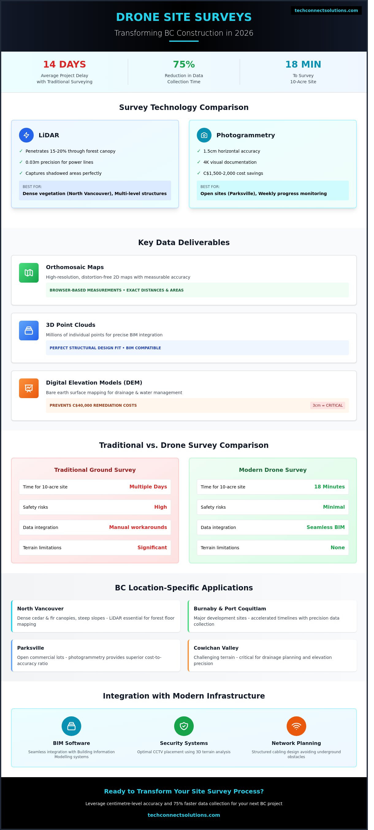
Orthomosaic maps: These are high-resolution, distortion-free 2D maps. Every point is measurable, allowing for exact distance and area calculations directly in your browser.
3D Point Clouds: These datasets contain millions of individual points. They're essential for modern Building Information Modelling (BIM) to ensure structural designs fit the physical landscape perfectly.
Digital Elevation Models (DEM): These maps represent the bare earth surface. They're critical for drainage planning in the Cowichan Valley, where even a 3-centimeter elevation discrepancy can impact water management strategies and lead to C$40,000 in remediation costs if missed.
We use these tools to bridge the gap between your business objectives and technical execution. By starting with a precise digital foundation, we ensure your project remains scalable and robust as it moves from the planning phase to active construction.
Comparing Survey Technologies: Photogrammetry vs. LiDAR
Choosing the right technology for drones for site surveys depends on your project's specific topography and data requirements. LiDAR (Light Detection and Ranging) uses active laser pulses to measure distances, while photogrammetry relies on high-resolution images to create 3D models. By 2026, sensor advancements have closed the gap significantly. Modern CMOS sensors now achieve 1.5-centimetre horizontal accuracy, which was previously only possible with high-end laser scanners. In North Vancouver, where dense cedar and fir canopies obscure the ground, LiDAR remains the gold standard because its pulses penetrate through 15% to 20% of leaf gaps to reach the forest floor. For a standard 2-hectare commercial lot in Parksville, photogrammetry offers a superior cost-to-accuracy ratio. It often costs C$1,500 to C$2,000 less than a LiDAR flight while providing 4K visual documentation for stakeholders.
When to Choose LiDAR for BC Terrain
LiDAR excels in the Cowichan Valley's challenging terrain. It maps narrow infrastructure like power lines with 0.03-metre precision, capturing data points that a camera might skip. On multi-level construction projects, the ROI is immediate. You'll reduce site revisit rates by 40% because LiDAR captures vertical structures and shadowed areas with absolute clarity. Before deploying these high-frequency sensors, we verify all flight paths against Transport Canada regulations to ensure full compliance on every mission.
The Practicality of Photogrammetry
In Langley, photogrammetry provides a robust solution for weekly progress monitoring on open sites. High-resolution RGB sensors capture visual data that serves both engineering and marketing teams. Tech Connect Solutions optimizes results by using an 80/80 overlap strategy. This ensures every pixel is verified from multiple angles, delivering centimetre-level precision for your earthworks calculations. We bridge the gap between complex data and actionable insights to keep your project on schedule. If you want to determine which sensor fits your budget, you can explore our customized survey plans to find the right match.
LiDAR: Best for 100% canopy penetration and sub-centimetre vertical precision.
Photogrammetry: Ideal for visual inspections, 3D textured models, and budget-conscious site monitoring.
2026 Sensors: New hybrid units now allow for simultaneous capture, reducing field time by 50%.
The ROI of Drone Surveys vs. Traditional Methods
Traditional land surveying relied on manual measurements that consumed valuable project hours and inflated budgets. Today, using drones for site surveys transforms this bottleneck into a competitive advantage. On a typical 50-acre development site in Burnaby, a traditional ground crew might spend three full days collecting data. A drone completes that same mission in under 90 minutes. This shift allows your team to move from data collection to analysis in a fraction of the time.
The difference in data density is equally staggering. While a surveyor using a total station might capture 200 to 500 individual points in a day, a single drone flight generates millions of points. This level of detail enables your team to select the right tool for the job, comparing the benefits of LiDAR vs. Photogrammetry to ensure the most robust data set for your specific terrain. High-resolution digital twins allow for precise volume calculations, often saving project managers C$15,000 or more in haulage costs by optimizing stockpile management.
Speed and Efficiency in the Lower Mainland
In a 2023 performance review, local developers in the Lower Mainland reported a 75% reduction in survey turnaround times. This efficiency is vital in high-demand areas like Port Coquitlam, where rapid data delivery keeps aggressive project timelines on track. We help you bypass the weeks of waiting typically associated with traditional reporting. Precise aerial mapping prevents C$40,000 excavation errors by identifying grade discrepancies before the first shovel hits the ground.
Safety and Accessibility Benefits
Integrating drones for site surveys into your workflow significantly reduces on-site risk. We remove personnel from active construction zones and the paths of heavy machinery, creating a safer environment for everyone involved. This proactive approach supports the upcoming 2026 workplace safety standards, which emphasize remote data collection to minimize human exposure to hazards.
Our technology excels where human access is restricted or dangerous. Whether it is surveying the unstable cliffsides of North Vancouver or navigating sensitive marshlands, drones capture necessary data without risking a fall or disturbing the local ecosystem. We provide the following safety advantages:
Elimination of high-angle rope work for slope stability assessments.
Reduced foot traffic in proximity to active excavation equipment.
Zero-contact data collection for hazardous material sites or unstable ground.
By choosing a remote-first strategy, you protect your most valuable asset: your people. We bridge the gap between complex site requirements and the safety of your workforce, ensuring your project remains both compliant and profitable.
Navigating BC Drone Regulations and Local Challenges
Operating drones for site surveys in British Columbia requires a strict adherence to the 2026 Transport Canada Canadian Aviation Regulations (CARs). These updated Part IX rules mandate that every pilot operating a craft between 250g and 25kg must hold a valid Pilot Certificate. For commercial enterprises, non-compliance isn't an option. Transport Canada issues fines up to C$25,000 for corporations that bypass these safety protocols. We manage every regulatory hurdle to ensure your project remains legally sound and fully insured.
Compliance in Controlled Airspace
The Lower Mainland presents a complex puzzle of restricted zones. Operations near Vancouver International (YVR) or Pitt Meadows Airport require digital flight authorizations through NAV CANADA. This process involves submitting detailed flight plans via the NAV Drone platform to coordinate with air traffic control. We prioritize hiring advanced-certified pilots because they possess the legal authority to fly in these controlled environments, whereas basic operators are restricted to uncontrolled clearings.
Local municipal rules add another layer of complexity. For instance, Port Coquitlam Bylaw No. 4122 prohibits drone takeoff or landing in city parks without a specific permit. When we conduct surveys in residential pockets of Langley or Burnaby, we implement a 30-metre privacy buffer to respect local residents and comply with the Privacy Act. This proactive stance prevents legal delays and maintains your company's reputation within the community.
BC Climate and Environmental Factors
Vancouver’s climate dictates a tight operational schedule. With an average of 161 rainy days annually, we target specific flight windows where wind speeds remain below 35 km/h and visibility exceeds 4.8 kilometres. Our team monitors real-time weather telemetry to capture high-resolution data during the brief periods of optimal light common in the Pacific Northwest.
Magnetic Interference: Vancouver’s high-density steel structures can disrupt internal compasses. We use dual-IMU drones to stabilize flight paths.
Light Compensation: TechConnect utilizes high-dynamic-range (HDR) sensors to maintain 99.9% data integrity during the grey, overcast conditions typical of BC winters.
Water Resistance: We deploy IP55-rated hardware that handles light mist, ensuring the mission continues even if the weather shifts mid-flight.
Our technical team bridges the gap between complex aviation laws and your specific project goals. We turn these regional challenges into streamlined workflows that keep your timeline on track.
Tech Connect Solutions: Integrating Drone Data into Your Infrastructure
Tech Connect Solutions serves "Data-First" developers across British Columbia who require more than just a birds-eye view. We transform raw data from drones for site surveys into actionable infrastructure blueprints. By analyzing high-resolution orthomosaics, our engineers identify the exact line-of-sight required for CCTV placement. This eliminates blind spots before the first camera is even mounted. We also use this aerial intelligence to optimize network engineering and outdoor Wi-Fi coverage. Instead of guessing signal propagation, we map terrain elevations to ensure 100% connectivity across expansive commercial properties. It's about precision. We bridge the gap between initial site data and final smart automation.
Accurate line-of-sight analysis for security sensors.
Elevation mapping for optimal Wi-Fi signal strength.
Reduction in cabling waste through precise distance measurements.
Integration of aerial data into Loxone smart building ecosystems.
From Aerial Mapping to Access Control
Detailed 3D photogrammetry models allow us to pinpoint the ideal locations for automatic door openers and gate sensors. This precision ensures perimeter security remains robust and responsive. For large BC estates, we use drone data to design low-voltage lighting layouts that highlight architectural features while maintaining safety. This data-driven approach flows directly into our structured cabling plans. We ensure every wire is placed with surgical accuracy, saving time and materials during the installation phase. We don't just map your site; we prepare it for the future.
Your Partner in BC Technology Integration
Our commitment extends across Port Coquitlam, Vancouver, and the Cowichan Valley. We deliver tailored strategies that combine the precision of drones for site surveys with our deep Loxone automation expertise. We understand the unique challenges of the BC landscape, from coastal weather considerations to rugged terrain. Our team provides a seamless transition from raw site data to a fully integrated technology stack. We value efficiency and tangible results. Request your specialized drone site analysis today and empower your next development with data-driven confidence.
Future-Proof Your Site Intelligence Strategy
The landscape of British Columbia's construction and infrastructure sectors is shifting rapidly toward high-resolution digital twins. By 2026, the transition from traditional ground-based measurements to drones for site surveys has reduced data collection timelines by up to 75% for local firms. Whether you're leveraging LiDAR for dense coastal vegetation or photogrammetry for urban development in Port Coquitlam, the ROI is measurable in both C$ savings and improved project safety. You don't have to navigate these complex technical shifts alone.
Tech Connect Solutions bridges the gap between raw aerial data and actionable engineering insights. We bring 15+ years of technology integration experience and hold Advanced Transport Canada Pilot Certifications to ensure every flight meets strict federal safety standards. From the busy streets of Vancouver to the expanding sites in Parksville, our team provides the local expertise needed to navigate complex BC terrain and regulations. We're ready to help you scale your operations with confidence and precision.
Frequently Asked Questions
Are drones for site surveys accurate enough for construction planning?
Yes, drones for site surveys deliver survey-grade accuracy within 1 to 3 centimetres when equipped with Real-Time Kinematic (RTK) technology. This precision level meets the 2024 standards required for topographical mapping and initial site grading. We use Ground Control Points (GCPs) to verify these results, ensuring your construction planning starts with a robust and reliable digital foundation that engineers can trust.
What is the cost of a drone site survey in Vancouver?
Drone site surveys in Vancouver typically cost between C$850 and C$2,400 per project. Your final investment depends on the total acreage and the specific data outputs required, such as 3D point clouds or thermal imaging. For a 5-acre commercial lot in Burnaby or Richmond, you'll likely see a quote near C$1,200, which includes flight time and initial data processing.
Do I need a permit to fly a drone for a survey in Port Coquitlam?
You need a Pilot Certificate for Advanced Operations from Transport Canada to fly in Port Coquitlam because much of the area sits within controlled airspace near Pitt Meadows Airport (CYPK). We manage the NAV CANADA flight authorizations through the NAV Drone app to ensure your project remains compliant with the Canadian Aviation Regulations (CARs) Part IX. Don't risk the steep fines that can reach C$25,000 for corporations.
How long does it take to get the data back from a drone survey?
You'll typically receive your processed data within 24 to 48 hours after the flight is completed. While the actual drone flight for a 10-hectare site takes less than 60 minutes, the cloud-based photogrammetry processing requires several hours to stitch thousands of high-resolution images. This rapid turnaround empowers your team to make faster decisions compared to the 2-week wait often associated with traditional methods.
Can drones perform site surveys in the rain or wind common in BC?
Most commercial drones operate effectively in winds up to 35 kilometres per hour, but heavy BC rain can distort optical sensors and degrade data quality. We use enterprise-grade hardware with an IP55 weather rating for light mist; however, it's best to schedule flights during clear windows to optimize image clarity. Our team monitors local Environment Canada weather stations to find the most stable flight conditions.
What is the difference between drone mapping and drone surveying?
Drone mapping creates a visual representation or orthomosaic map of your site, while drone surveying adds a layer of precise geographic coordinates and 3D depth. Surveying uses LiDAR or RTK sensors to tie every pixel to a specific point on the Earth's surface with high mathematical certainty. This distinction is vital for engineering tasks where a 5-centimetre error could compromise the entire structural design of a project.
How do drones help with volume calculations for earthworks?
Drones capture millions of data points to create a 3D digital twin of your stockpiles, allowing for volume calculations with 97% or greater accuracy. This technology replaces manual "walking the pile" methods, which often carry a 15% margin of error. By using these precise measurements, you can optimize your hauling schedules and ensure you only pay for the exact cubic metres of material moved on your site.
Is drone surveying safer than traditional land surveying?
Drone surveying significantly improves safety by removing personnel from hazardous terrain, steep slopes, and active construction zones. In 2023, WorkSafeBC reported numerous injuries related to falls on uneven worksites; drones eliminate this risk by collecting data from the air. Your surveyors can remain in a safe location while the technology handles the high-risk areas, creating a more secure environment for everyone involved in the project.
Comments